Published: November 2013
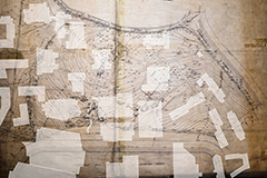
After purchasing 35 acres in Chestnut Hill in December 1907, Boston College commissioned a topographic survey of its new holding. The resulting map, completed in August 1908, measures roughly 4 x 5 feet. It describes the rectangle formed by Beacon Street and Commonwealth Avenue, South Street (now College Road) and the western edge of the reservoir called Lawrence Basin (now the Lower Campus).
To see how the Boston College campus filled in this farmscape, move your cursor around the map.