
| Date | 1755 |
| Publish_location | Leipzig |
| Publisher | Merkur |
| Collection | Ricci Institute Library [TKE] |
| Language | German |
| Record_type | Map, Map (Digital) |
| Shelf | Digital Archives, Map Case |
| Call Number | G2306.S1 1755 B466 |
| Description | color map ; 277 x 313 mm. |
| Note | China nebst Corea, und den benachbarten Laendern der Tartarey : Aus denen Karten genommen, welche die Jesuiten von dem Jahre 1708 bis 1717 davon entworfen haben / Nicolaus Belin. Acquisition is made possible by the Thomas J. Klitgaard Endowment at the Ricci Institute. |
| Subject | China--Maps--Early works to 1800 Jesuits--China--16th-18th centuries--Contributions in cartography--Sources Korea--Maps--Early works to 1800 |
| Multimedia |  |
| Date | 1764 |
| Publish_location | Paris |
| Publisher | --- |
| Collection | Ricci Institute Library |
| Language | French |
| Record_type | Map |
| Shelf | Map Case |
| Call Number | G7823.M2 1764 .B38 |
| Description | 1 map : color ; 17 x 21 cm |
| Note | Plan de la ville et du port de Macao / par N.B., Ingr. [i.e Ingénieur] de la Marine. Relief shown pictorially and by hachures. In lower right margin: Tome V, no. 17. Extracted page from Atlas. Slight water stains. Coloring and grid layout of Fort. area differs from other examples. |
| Subject | Macau 澳門--Maps--18th century Harbors--Macau--Maps--18th century |
| LCCN | 89696136 |
| Multimedia | 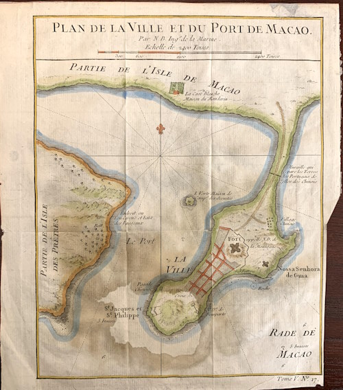 |
