Published: October 2005
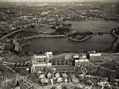
Between 1907, when President Thomas I. Gasson purchased 31 acres of farmland in Chestnut Hill as a new site for Boston College, and the late 1970s, when the outline of the residential village on the Lower Campus was taking final shape, scores of aerial photographs were taken of Boston College, nearly all by entrepreneurial pilots who’d been hired to photograph other sites and who thought they’d chance a few shots of the campus as they passed by and might later sell them to the University.
Of some 40 photographs that Boston College acquired over the years and that are now in the Burns Library archives, @BC presents 15 that illustrate the growth of the University from a small Gothic academic center perched on a bluff above a reservoir, to the multi campus institution that by the mid-1970s had begun to make its run at becoming a nationally known university.