
| Author | Stackhouse, Thomas, 1756-1836 Neele, Samuel John, 1758-1824 |
| Place | London |
| Publisher | [Thomas Stackhouse] |
| Collection | Ricci Institute Library |
| Language | English |
| Type | Map |
| Shelf | Map Case |
| Call Number | G7400 1783 .S78 |
| Description | 1 map : color ; 36.5 x 36.5 cm |
| Note | Asia Antiqua / [Thomas Stackhouse] Engraved without attribution by Samuel John Neele. Date uncertain: similar examples dated 1782, 1793. |
| Multimedia | 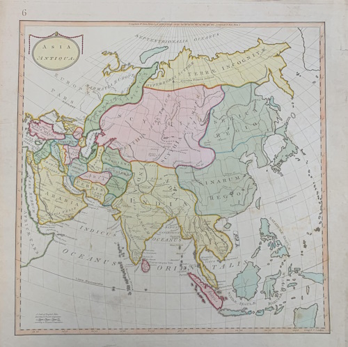 |
| Author | Hondius, Jodocus, 1563-1612Jansson, Jan, 1588-1664 |
| Place | Amstelodami |
| Publisher | Apud Iohannem Ianssonium |
| Collection | Ricci Institute Library |
| Language | Latin |
| Type | Map |
| Shelf | Map Case |
| Call Number | G7400 1641 .H6 |
| Description | 1 map : hand colored ; 375 x 495 mm |
| Note | Asia recens summa cura delineata / Auct. Henr. Hondio 1641. Asia recens summa cura delineata A superb and highly detailed seventeenth century map of Asia, by Henricus Hondius and published by Jan Jansson in his 1641 Latin edition of the Atlas Novus. The plate from which this map was printed was originally one of the celebrated Hondius cartes-a-figure maps, featuring border vignettes of principal Asian cities and figures in various types of national dress. Because most of these maps were too large to fit neatly into later atlas printings by Hondius and Jansson, the decorative borders were often removed or blocked out, which is why the border measurements on this example only feature on three of the four sides. In the current example, the continent of Asia is shown, with adjoining sections of Africa and Europe, and with the westernmost reaches of North America visible at the top right corner of the map, behind a dedicatory cartouche. The borders and coasts of the various empires and nations of Asia are outlined in _hand colour, and principal cities are picked out in red, as is the path of the Great Wall, separating a slightly truncated China from the lands of Tartaria. An elephant runs across a nver delta to the east of India, roughly equivalent with modern day Bhutan and Bangladesh, while a pair of lions occupy the Libyan desert to the west of the Nile River. The Arabian peninsula is divided into Arabia Deserta and Arabia Felix, and the Persian empire stretches from the Gulf to the banks of the Mahi River. In the far east, Korea is shown correctly as a peninsula rather than an island, a cartographic improvement on the very similar figure card by Blaeu, Hondius' chief commercial rival. Japan, however, retains the horizontal orientation typical of maps of this era, following the surveys of Luis Teixeira, and the map of Ortelius. A number of the islands of the South East Asian archipelago are still unmapped, or only partially depicted, most notably Borneo, Java, and the Celebes. New Guinea is absent, as are any suggestions of the top of Australia, though the island of Ceiram probably represents the northwest Papuan seacoast. The seas of the Pacific and Indian oceans feature numerous sailing ships and sea monsters, the most notable of which is a horned triton, who blows a horn in the sea between Sumatra and the Maldives. At the top left comer, the title is enclosed in a baroque cartouche supported by a pair of northern Asian nomads, possibly Tartars or Bactrians. Henricus Hondius (1597 - 16th August 1651), often called Hendrik Hondius the Younger to differentiate him from the earlier, and unrelated portrait engraver Hendrik Hondius the Elder, was the son of the famous cartographer J odocus Hondius. Like his father, Henricus was an engraver, cartographer, and publisher. He first came to prominence through his publication in 1606 of a new version of Mercator's 1569 World Map, the plates for which he had obtained from Mercator's grandson Rumold. Following his father's death, Henricus co-ran the family business, eventually partnering with his brother-in-law, Jan Jansson. Johannes Janssonius (1588 - 1664) was a famed cartographer and print publisher. More commonly known as Jan Jans son, he was born in Arnhem where his father, Jan J anszoon the Elder, was a bookseller and publisher. In 1612 he married the daughter of the cartographer and publisher Jodocus Hondius, and then set up in business in Amsterdam as a book publisher. In 1616 he published his first maps of France and Italy and from then onwards, produced a very large number of maps which went some way to rival those of the Blaeu family, who held a virtual monopoly over the industry. From about 1630 to 1638 he was in partnership with his brother-in-law, Henricus Hondius, issuing further editions .of the Mercator/Hondius atlases to which his name was added. On the death of Hondius he took over the business, expanding the atlas still further, until eventually he published an eleven volume Atlas Major on a scale similar to Johannes Blaeu's magnum opus. After Jansson's death, his heirs published a number of maps in the Atlas Contractus of 1666, and, later still, many of the plates of his British maps were acquired by Pieter Schenk and Gerard V alck, who published them again in 1683 as separate maps.
Sanders [49043] |
| Multimedia |  |
| Author | |
| Place | London |
| Publisher | Henry Seile |
| Collection | Ricci Institute Library |
| Language | Latin |
| Type | Map [copper engraved] |
| Shelf | Map Case |
| Call Number | G4700 1657 .H49 |
| Description | map : hand-colored copper engraving ; 340 x 440 mm |
| Note | Asiae Descriptio Nova / Seile, Henry A beautiful mid-seventeenth century map of Asia, engraved by John Goddard for Henry Seile's 1657 second edition printing of Peter Heylyn's Cosmographie in faure Bookes, Contqyning the Chorographie & Histon·e of the whole World, and all the Principal! Ivngdoms, Provinces, Seas, and Isles Thereof. The map, one of the earliest English maps of the continent, shows the whole of Asia, as well as adjoining parts of Europe, Africa, and the easternmost part of North America, with the borders of the various kingdoms and nations outlined in beautiful hand colour. The Arabian peninsula is split in two, into Arabia Deserta and Arabia Felix, while 'Natalia' encompasses most of Mesopotamia, Cyprus, Crete and the Dodecanese, and most of the Levantine coast and parts of Syria. Persia stretches to the banks of the Ganges, and China's geographic width is very constricted. An elephant sits above the delta of modern day Bangladesh, and the Great Wall of China is shown pictorially and picked out in red. Korea is shown correctly as a peninsula, though Japan's right angled orientation follows the earlier map of Ortelius, based upon the survey of the Jesuit Luis Teixera. In southeast Asia, Java is only partially shown, Sulawesi's eastern coast is sketchy, and West Papua is unlabelled and poorly Peter Heylyn (1599-1662) was an English churchman and author, particularly well known for his geographical and historical treatises, the Microcosmus (1621) and the Cosmographie (1652). Born in Burford, Oxfordshire, Heylyn attended Hart Hall in Oxford. He was made a Fellow of Magdalen at the age of 18, and lectured on geography, particularly classical and biblical. In his ecclesiastical roles, he was notorious as an anti-Puritan controversialist. This, combined with his former royal patronage, stymied his career during the Commonwealth period. Geographically, his work is significant as being among, if not the, first printed descriptions of Australia, California, and the Tierra del Fuego, and, like others of his era, he objected to the use of 'America' to describe the New World, preferring titles that derived from Columbus or Cabot, rather than Vespucci. |
| Author | Ortelius, Abraham, 1527-1598 |
| Place | Antverpiæ [Antwerp] |
| Publisher | --- |
| Collection | Ricci Institute Library |
| Edition | First Edition |
| Language | Latin |
| Type | Map |
| Shelf | Map Case |
| Call Number | G7400 1570 .O78 |
| Description | 1 map : hand colored ; 38 x 49 cm. |
| Note | Asiae Nova Descriptio / [Abraham Ortelius].
Description: Nice full color example of Ortelius' map of Asia, from Ortelius' Theatrum Orbis Terrarum, the first modern world atlas. A marvelous misprojection of Japan and Southeast Asia. Very distinct Northeast Passage. Includes sailing ships and other embellishments. The map is based upon Ortelius's wall map of Asia, which in turn draws its cartographic data from Gastaldi and Albufeda.
Online at Antique Maps. |
| Author | L'Isle, Guillaume de, 1675-1726Cóvens et Mortier |
| Place | Amsterdam |
| Publisher | Chez Jean Cóvens & Corneille Mortier |
| Collection | Ricci Institute Library |
| Language | French |
| Type | Map |
| Shelf | Map Case |
| Call Number | Map [G2201.S1 L58 1742] |
| Description | 1 map : hand col. ; 61 x 63 cm. |
| Note | Carte des Indes et de la Chine : dressée sur plusieurs relations particulières rectifiées par quelques observations / par Guillaume de l'Isle de l'Academie Royale des Sciences. Scale [ca. 1:10,700,000] (E 58°--E 159°/N 50°--S 9°). Sanders 34956. From Dutch ed. entitlted: Atlas nouveau, contenant toutes les parties du monde, ou sont exactement remarquées les empires, monarchies, royaumes, etats, republiques &c. / par Guillaume de l'Isle, premier géographe de sa Majesté. Relief shown pictorially. Prime meridian: Ferro. Originally issued on 2 sheets. See David Rumsey Collection. |
| Author | Chang, Min-min [Zhou Minmin 周敏民]Hong Kong University of Science and Technology Library 香港科技大學圖書館 |
| Place | Hong Kong 香港 |
| Publisher | Hong Kong University of Science and Technology Library |
| Collection | Ricci Institute Library |
| Language | English-Chinese |
| Type | Atlas |
| Shelf | Stacks |
| Call Number | G2306.S1 C3 2003 |
| Description | 1 atlas (vii, 203 p.) : color maps ; 34 x 38 |
| Note | China in European maps : a library special collection / compiled and edited by Min-min Chang = Ditu Zhongguo : tu shu guan te cang 地圖中國 : 圖書館特藏 / bianjizhe Zhou Minmin 編輯者周敏民. "This catalog contains fifty-five maps held in the Special Collections Department of the Hong Kong University of Science and Technology Library. The collection 'vividly reflects Europe’s lasting fascination and cross-cultural exchange with China over many centuries.' Many early maps of China were based on Jesuit models, for example, plate 28 by Joan Blaeu after Martini and plate 29 by Nicolas Sanson after Ricci. |
| ISBN | 9628640399 ; 9789628640393 |
| LCCN | 2004627563 |
| Author | Manesson-Mallet, Allain, ca. 1630-ca. 1706 |
| Place | Paris |
| Publisher | [D. Thierry] |
| Collection | Ricci Institute Library |
| Language | French |
| Type | Map [copper engraved] |
| Shelf | Map Case |
| Call Number | G7400 1683 .M37 |
| Description | 1 map : copper engraved with hand coloring ; 149 x 103 mm |
| Note | Grand Tartarie / [ Allain Manesson-Mallet] Extract from A.M. Mallet's Description de l'univers, fig. IV. (De L'Asie p.13) Map of Asia: Ocean Septentrional, Mer de Tartarie, Tartarie Vraye, Tangut, Catay, Chine, Tibet, Lassa, Inde, Moscovie Deserte, Kalmouques, Turquestan, Usbeck, Perse... |
| Multimedia | 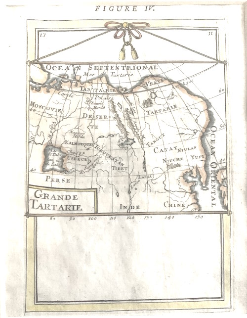 |
| Author | Brion de la Tour, Louis, fl. 1756 -1823 |
| Place | Paris |
| Publisher | Chez le Sr. Desnos rue St. Jacques au Globe |
| Collection | Ricci Institute Library |
| Language | French |
| Type | Map |
| Shelf | Map Case |
| Call Number | [1] |
| Description | 1 map ; engraved, color ; 23 x 25.5 cm. |
| Note | Grande Tartarie et isles du Japon / par Mr. Brion. [Ca. 1:32 000 000] (E 34°-W 169°/N 78°-N 30°) See high resolution example at e-rara website. |
| Multimedia |  |
| Author | Vaugondy, Robert de, 1688-1766Delamarche, Charles-François, 1740-1817 |
| Collection | Ricci Institute Library |
| Language | French |
| Type | Map |
| Shelf | Flats, Room 104C 1 |
| Call Number | G7400.V384 1795 |
| Description | Map ; 27 x 24 cm. |
| Note | L'Asie [map] / Robert de Vaugondy, 1688-1766; Charles-François Delamarche, 1740-1817 Map dated "an IIIe de la République Française." |
| Author | Nebenzahl, Kenneth, 1927- |
| Place | London |
| Publisher | Phaidon |
| Collection | Ricci Institute Library |
| Language | English |
| Type | Atlas |
| Shelf | Director's Office |
| Call Number | G2201.S1 N4 2004 |
| Description | 1 atlas (176 p.) : ill. (chiefly col.), maps ; 26 x 30 |
| Note | Mapping the Silk Road and beyond : 2,000 years of exploring the East / Kenneth Nebenzahl. |
| ISBN | 0714844098 ; 9780714844091 |
| LCCN | 2005416338 |
| Author | Hostetler, Laura |
| Place | Leiden ; Boston |
| Publisher | Brill |
| Collection | Ricci Institute Library |
| Language | English, Chinese |
| Type | Maps/Atlas |
| Series | Studies in the history of Christianity in east Asia ; 9 |
| Shelf | Digital Archives, Seminar Room 102-103 |
| Call Number | G2201.S1 R4 2024 |
| Description | 1 atlas (xxxii. 395 p. : color maps ; 24 cm) + pdf |
| Note | Reimagining the globe and cultural exchange : the East Asian legacies of Matteo Ricci's world map / edited by Laura Hostetler. Includes bibliographical references and index. Foreword: Maps, Missionaries, and the Global Exchange of Knowledge in the Early Modern World / M. Antoni J. Ucerler, S.J. Part 1. Jesuit Circuits of Communication and Publication Part 2. Jesuit World Maps in Chinese, from Ricci to Verbiest Postlude. Reflections on the Curation of Cartographic Knowledge "How did Asia come to be represented on European World maps? When and how did Asian Countries adopt a continental system for understanding the world? How did countries with disparate mapping traditions come to share a basic understanding and vision of the globe? This series of essays organized into sections on Jesuit Circuits of Communication and Publication; Jesuit World Maps in Chinese; Reverberations of Matteo Ricci's Maps in East Asia; and Reflections on the Curation of Cartographic Knowledge, go a long way toward answering these questions about the shaping of our modern understandings of the world"-- Provided by publisher. Local access dig.pdf [Reimagining the Globe.pdf] |
| ISBN | 9789004682665 ; 9789004684782 |
| LCCN | 2023055072 |
| Multimedia |  |
| Author | Ortelius, Abraham, 1527-1598 |
| Place | Antverpiæ [Antwerp] |
| Publisher | --- |
| Collection | Ricci Institute Library |
| Language | Latin |
| Type | Map |
| Shelf | Map Case |
| Call Number | G7270 1595 .O7 [45192] |
| Description | 1 map ; 35 x 47 cm. |
| Note | Tartariae Sive Magni Chami Regni tÿpus / [Abraham Ortelius]. Decorative example of Ortelius' map of Tartary, Japan, and the West Coast of North America, from the 1595 Latin edition of Ortelius' Theatrum Orbis Terarrum, the first modern atlas of the World. The map provides a remarkable early representation of what was then the Tartar Kingdom, extending from the Caspian Sea in the west, to China, Japan and Russian, in Asia, in the east. It also includes a remarkable early treatment of the Northwest Coast of America, California, and the Southwestern US. The map is the earliest obtainable map to name California, and includes the 7 cities of Cibola in the Southwestern US, although only 6 cities are actually shown. The Straits of Anian are also named. The Nephalites are named Neptali after one of the 10 tribes with a Hebrew name, and after the Danites, who by way of punishment were called the Danes of the dark North, and they were on account of the claims of Rachel Balbah placed to the side, in the area of the Hudores or Iehudeores; in the year 416 they were victorious in their battle against Perosa. Others call them incorrectly Euthalites. The Scythian ocean, according to Plinius, has sweet water, and he also says it contains many islands, as M. Paulus [Marco Polo) also says, but neither of the two tells about their number or location. Tabor or Tybur, center of the area of the Tartars, where once the Holy Books got lost, yet they are united under one king, who in 1540 first reached France and king Franciscus, and later, at the initiative of Charles the Fifth was burnt at the stake for his heresy, because he had secretly endeavoured to convert Christian kings to the Jewish religion, about which he had spoken with Charles the Fifth. Here the ten tribes retreated, and changed from the Tatar or Tartar area to Scythia. Since then they are called Gauths or Gauthens, confirming Gods highest glory, and here lies the splendid kingdom of Cathai. Turkestan. The area from which the 10 tribes as allies living on this side of the mountain range have been called 900 years ago by the Persians to fight the armies of Ismael the Muslim. Dig. [Ortelius-Tartariae Sive Magni Chami Regni tÿpus] |
| Multimedia |  |
| Author | Forêt, Philippe, 1957-Kaplony, AndreasEidgenössische Technische Hochschule Zürich |
| Place | Leiden ; Boston |
| Publisher | Brill |
| Collection | Ricci Institute Library |
| Language | English |
| Type | Digital Book (PDF) |
| Series | Brill's Inner Asian library ; v. 21 |
| Shelf | Digital Archives |
| Call Number | GA1081.J68 2008d |
| Description | pdf [xxxi, 243, [31] p. : ill. (some color), maps] |
| Note | The journey of maps and images on the Silk Road / edited by Philippe Forêt, Andreas Kaplony. Foreword / Lorenz Hurni -- Preface : what is a map? / Valerie Hansen -- Introduction / Philippe Forêt and Andreas Kaplony -- Traces of the Silk Road in Han-Dynasty iconography : questions and hypotheses / Nicolas Zufferey -- Visualizing pilgrimage and mapping experience : Mount Wutai on the Silk Road / Natasha Heller -- The mapping of sacred space : images of Buddhist cosmographies in medieval China / Dorothy C. Wong -- Lost in translation : gridded plans and maps along the Silk Road / Jonathan M. Bloom -- Square horoscope diagrams in Middle Eastern astrology and Chinese cosmological diagrams : were these designs transmitted through the Silk Road? / Johannes Thomann -- The intrusion of East Asian imagery in thirteenth-century Armenia : political and cultural exchange along the Silk Road / Dickran Kouymjian -- Comparing al-Kāshgharī's map to his text : on the visual language, purpose, and transmission of Arabic-Islamic maps / Andreas Kaplony -- The Book of curiosities : a medieval Islamic view of the East / Yossef Rapoport -- Celestial maps and illustrations in Arabic-Islamic astronomy / Paul Kunitzsch -- Revisiting Catalan portolan charts : do they contain elements of Asian provenance? / Sonja Brentjes -- Conclusion / Philippe Forêt and Andreas Kaplony -- Appendix. List of geographical nomenclature in al-Kāshgharī's text and map / Andreas Kaplony. Covers the diffusion and transmission of geographical knowledge that occurred at critical junctures in the long history of the Silk Road. In retracing the steps of four major circuits across the many civilizations that shared the Silk Road, this work traces the ways in which maps and images surmounted spatial, historical and cultural divisions. Local access dig.pdf. [Foret-Silk Road.pdf] |
| ISBN | 9789047424970 ; 9047424972 |
| LCCN | 2008040532 |
| Multimedia |  |
| Author | Scherer, Heinrich [Henricus], 1628-1704 |
| Place | [Munich] |
| Publisher | Heinrich Scherer |
| Collection | Ricci Institute Library |
| Language | Latin |
| Type | Map [copper engraved] |
| Shelf | Map Case |
| Call Number | G4700 1702 .S263 |
| Description | map, unmounted : 230 x 350 mm |
| Note | Totius Asiae Continens cum Praecipuis Insulis eidem Annexis / [Heinrich Scherer] Copper engraved Heinrich Scherer (1628-1704) was a German cartographer, geographer, engraver, and publisher. A Professor of mathematics at Munich University, Scherer was also a devout Catholic, a facet of his life that is immediately apparent in his published works. His most famous publication was the Atlas Sanders [45445] |
| Author | Xiang Da 向達, 1900-1966Mao Yuanyi 茅元儀, 1594-1640 |
| Place | Beijing 北京 |
| Publisher | Zhonghua shuju 中華書局 |
| Collection | Bibl. Sinensis Soc. Iesu |
| Edition | 第1版 |
| Language | Chinese 中文[繁體] |
| Type | Book, Digital Book (PDF) |
| Series | Zhong-wai jiaotong shiji congkan 中外交通史籍叢刊 ; 19 |
| Shelf | Digital Archives, Seminar Room 102-103 |
| Call Number | GA1081.M32 1961 |
| Description | 6, 66, 45 p., 47 p. of plates : ill., maps ;19 cm. |
| Note | Zheng He hanghai tu 鄭和航海圖 / [Mao Yuanyi 茅元儀] ; Xiang Da zhengli 向達整理. 鄭和航海圖見於明茅元儀編輯的武備志卷 240. Dig. access [Zheng He hanghai tu.pdf] |
| LCCN | 65001355 |
