
| Date | 1752 |
| Publish_location | Paris |
| Publisher | [Panckoucke, Stoupe, Brunet?] |
| Collection | Ricci Institute Library |
| Language | French |
| Record_type | Map [copper engraved] |
| Shelf | Map Case |
| Call Number | G9235 1752 .B8 |
| Description | 2 maps on 1 sheet : color ; 40 x 46 cm |
| Note | Carte des nouvelles découvertes / dressée par Phil. Buache, Pr. géogr? du Roi, presentée à l'Acad. des Sciences le 9 Aout 1752 et approuvée dans son assemblée du 6 Septembre suivant. Extrait d'une carte Japonaise de l'univers : apportée en Europe par Kaempfer et deposée dans le cabinet de feu Mr. Han Sloane, président de la Société royale de Londre. Map 1 (upper) Scale approximately 1:35,000,000. -- Map 2 (lower) Scale approximately 1:50,000,000. 2 maps on 1 sheet : hand colored, copperplate engraving ; 15 x 31 cm and 15 x 28 cm, sheet 40 x 46 cm Shows territories, bodies of water, routes of explorers, and notes on voyages and discoveries. Comparative cartography of the West Coast of North America and Northeast Coast of Asia, based upon Buache. The various Russian discoveries between 1731 and 1742 are shown in the upper map, including the Sea of the West and various explorers routes and notes. The bottom map is based upon a Japanese map taken by Kaempfer back to Europe. Diderot's work is part of a 10 map supplement to his Encyclopedia, and provides one of the most fascinating studies in contemporary comparative cartography which can be obtained by collectors, much of which is dedicated to the NW Coast. BLR#84038 |
| Subject | Japan--Maps--Early works to 1800 North Pacific Ocean--Maps--Early works to 1800 North America--Maps--Early works to 1800 Geographical myths--Maps--Early works to 1800 Northwest Passage--Maps--Early works to 1800 Arctic Regions--Maps--Early works to 1800 |
| Multimedia | 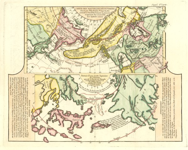 |
| Date | 1732 |
| Publish_location | Amsterdam |
| Publisher | Chez R. & I. Ottens |
| Collection | Ricci Institute Library |
| Language | Dutch-French |
| Record_type | Map |
| Shelf | Map Case |
| Call Number | G7961.P2 1732 .K34 |
| Description | 1 map : hand colored ; 30 x 37 cm. |
| Note | Particuliere reyskaart overland van Japan strekkende van Osaka tot Miaco, de zetel van den Geestelyken Keyzer van Japan, en van daar tot Jokaits = Carte de la route par terre depuis Osacca usqu'à Miaco, et depuis Miaco usqu'à Jokaitz / door Engelbert Kaempfer. Relief shown pictorially. Scale given in 'little' Japanese miles. Appears in: Kaempfer, Engelbert. Histoire naturelle, civile et ecclesiastique de l'empire du Japon ... Amsterdam 1732. (Tab. VIII. A). Online at Harvard Map Collection. |
| Subject | Japan--Maps--Early works to 1800 Roads--Japan--Maps--Early works to 1800 |
| Multimedia |  |
